

Being an aviator involves far more than knowing your way around a cockpit. Pilots must also interpret detailed weather reports that keep them safe in the air. Two of the most essential are METAR and TAF.
If you’re not yet fluent in these coded weather transmissions, have no fear. This guide will show you how to read a TAF and METAR so you can fly smart when the weather takes a turn.
In this article:
What Is METAR?
METAR (Meteorological Aerodrome Report) is a format for reporting weather observations at airports. It is the most common weather report that pilots rely on for accurate, up-to-date conditions before and during a flight.
These briefs provide critical details like wind, visibility, cloud cover and height, temperature, dew point, precipitation, and barometric pressure.
These reports are produced by weather stations located at airports around the globe. They are updated frequently throughout the day, so pilots and flight dispatchers can have the most current weather information at their fingertips.
METAR is so important in aviation because it offers a concise, coded overview of the weather conditions at an airport. This information helps pilots make informed decisions about everything: takeoffs, landings, and in-flight navigation.
There are two types of METAR reports: routine METARs and special (SPECI) reports. Routine METARs are transmitted at fixed time slots, while SPECIs are issued between them when there are significant weather changes.
Pilots access METAR reports through a few different channels.
You can get text-based METARs printed from flight planning apps, through ACARS datalink while in flight, or over air traffic control frequencies at airports. Nowadays, pilots often use apps and tablets to pull up METARs quickly.
What Is TAF?
Terminal Aerodrome Forecast (TAF) acts like a meteorological crystal ball for aviators. While METAR provides current weather conditions, reading a TAF gives pilots an outlook on what to expect in the coming hours. Together, they provide the full weather picture pilots require from departure to landing.
TAF reports are produced by meteorologists who analyze weather patterns, satellite imagery, and computer models. They issue TAF forecasts for major airports looking ahead 24-30 hours, with updates as weather evolves.
For us pilots, these forecasts allow better flight planning for areas that will see changing conditions.
TAF highlights crucial details in aviation you can’t find anywhere else. This includes things like expected cloud layers, visibility, wind shifts, precipitation, and thunderstorm chances.
Pilots can access TAFs through channels similar to METARs: aviation weather websites, dedicated meteorological services, and onboard avionics systems. The issuance of TAFs is regular, with updates provided at least four times a day.
In our experience, TAF demands even more decoding work from pilots. You’ll need to look at times, change indicators, probability forecasts, and references to adjacent airports. But trust us, the insight is so invaluable for flight planning and routing decisions.
How to Read a METAR Report
Decoding a METAR report might seem like unraveling a secret code at first. But once you get the hang of it, it’s pretty straightforward.
Let’s start with a sample METAR below:
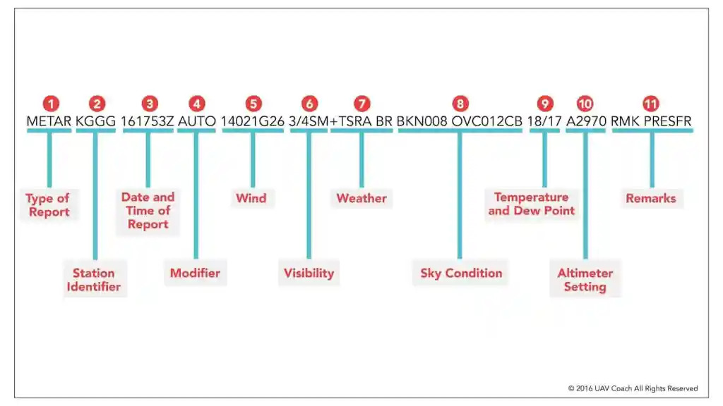
METAR KJFK 030951Z 18015G25KT 5SM RABR SCT020 BKN050 08/05 A2992 RMK AO2 SLP134
There are several parts. Each of them presents a piece of information about the weather conditions at JFK Airport at the time of the report.
Type of Report (METAR)
This part tells us it belongs to a standard hourly aviation routine weather report.
Station Identifier (KJFK)
The report kicks off with KJFK. This indicates it’s for JFK International Airport. This station identifier is a unique code assigned to each weather station, typically an airport.
The International Civil Aviation Organization (ICAO) standardizes these identifiers globally.
In the United States, these codes are prefixed with a K. Airport identifiers in other regions start with different letters: C in Canada, Y in Australia, E in Europe, etc.
Time of Report (030951Z)
After the station comes the observation time indicating when the METAR was issued. It’s given in Zulu time (UTC) and formatted as the day of the month followed by the time.
In our sample, 030951Z translates to the 3rd of the month at 09:51 UTC. So this would be a report taken at 4:51 am local New York time on the same day.
This universal time reference helps synchronize weather reports globally with clarity regardless of local time zones.
Wind Speed and Direction (18015G25KT)
Wind conditions are often described as DDDSSKT, where DDD is the wind direction, and SS is the speed. Wind direction can vary from 000 to 360 degrees, represented by three digits, and wind speed is always in knots. Additionally, gusts are marked by a ‘G’ followed by the gust speed in knots.
18015G25KT means the wind is coming from the south (180 degrees on a compass) with a speed of 15 knots. There are also gusts reaching up to 25 knots.
This surface wind may differ from winds aloft given by air traffic control at cruising altitude. However, the METAR provides the specific wind conditions pilots will experience closest to the runway during arrival and departure.
Prevailing Visibility (5SM)
Visibility is reported in statute miles and reflects the distance at which objects can be clearly seen.
Common values range from less than 1 mile in foggy conditions up to 10 miles in clear weather. In the example, 5SM indicates a visibility of 5 statute miles. Visibility can also be given in meters (7000 is approximately 7 kilometers visibility).
Weather Phenomena (RABR)
Significant weather phenomena at the time of observation are appended after the other elements.
They are coded with abbreviations to describe the current weather conditions.
Common weather codes include RA for rain, SN for snow, BR for mist, TS for thunderstorm, and FG for fog. A lack of a prefix or a “+” sign would indicate moderate or heavy intensity, respectively.
As you can guess now, -RA BR translates to rain and mist at the time of the report. Other examples, like +SN, would mean heavy snow.
Up to three major weather groups can be encoded, ordered by intensity. Phenomena are missing if no significant weather is observed.
Cloud Coverage (SCT020 BKN050)
Cloud coverage is typically reported in four main categories: few (FEW), scattered (SCT), broken (BKN), and overcast (OVC), each giving a rough idea of how much of the sky is obscured. Few means 1/8 to 2/8 of the sky is covered, scattered is 3/8 to 4/8, broken is 5/8 to 7/8, and overcast means the sky is entirely covered (8/8).
The number that comes after, like 020 and 050, is a bit more straightforward. It’s the altitude of the cloud base hundreds of feet above ground level. So, SCT020 means there are scattered clouds at 2000 feet and broken clouds at 5000 feet above ground level.
Temperature and Dew Point (08/05)
They are reported in a METAR with a simple format: two digits for temperature followed by a slash and then two digits for the dew point, both in degrees Celsius.
For example, 08/05 from our sample means the air temperature is 8°C, and the dew point is 5°C.
The dew point value is key here. It shows the temperature at which air becomes fully saturated with moisture. This situation can lead to the formation of dew, fog, or even precipitation if conditions allow.
Atmospheric Pressure (A2992)
This part shows the air pressure at the station location converted to sea level. This is presented with an “A” followed by a four-digit number representing the pressure in inches of mercury (inHg).
In our example, “A2992” translates to 29.92 inHg (an altimeter of 29.92 inches of mercury).
Higher pressure gives a higher altimeter setting, while lower pressure means a lower setting. Typical values range from A2950 to A3050 in METAR reports. Outside North America, it might be reported in hectopascals (hPa) or millibars (mb).
Remarks (RMK AO2 SLP134)
The remarks section (RMK) of a METAR is where you’ll find additional information not covered in the standard report.
This part can include details about weather phenomena, runway conditions, and more, depending on what’s relevant at the time of observation. In our example, RMK AO2 SLP134 breaks down as follows:
AO2 tells us that the station is automated with a precipitation sensor. This provides us with information on the type of equipment monitoring weather conditions and its capabilities.
SLP means sea-level pressure. The following three digits (plus a decimal point assumed before the last digit) represent that pressure in hectopascals.
Here, 134 translates to 1013.4 hPa, a standard way to denote atmospheric pressure without using the leading 10 or 9.
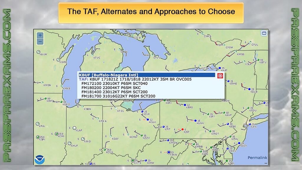
How to Read a TAF Forecast
We’re going to decode a TAF for JFK Airport issued at the same time as our METAR example:
TAF KJFK 030951Z 0310/0412 09010KT P6SM FEW020 SCT050
TEMPO 0312/0316 5SM -RA BR BKN020
FM031600 18015G25KT P6SM VCSH SCT020 BKN035
The initial segment of a TAF report, “TAF KJFK 030951Z,” might look familiar if you’ve already learned about METARs. While the structure mirrors that of METAR, TAF comes with other parts to emphasize the forecast’s timing and applicability.
Forecast Period (0310/0412)
The forecast period in a TAF tells us the forecast’s duration (or how long a TAR is valid for). This is always given in a day/time format, highlighting when the forecast starts and ends.
The first two digits represent the day of the month, and the last two digits represent the time in UTC (Coordinated Universal Time).
So, 0310/0412 means the forecast starts at 10:00 UTC on the 3rd of the month and ends at 12:00 UTC on the 4th. This gives pilots and flight planners a temporal window for the expected weather conditions at the airport.
In TAFs, you’ll encounter various forecast periods, each tailored to the specific needs of the aviation community. These periods can range from short-term forecasts covering just a few hours to more extended forecasts lasting up to 30 hours.
Forecast Period Conditions (09010KT P6SM FEW020 SCT050)
After decoding the initial parts of our TAF report, we hit the forecast conditions line: 09010KT P6SM FEW020 SCT050.
This part outlines the expected weather during a specified forecast period. It directly influences flight planning and operations. Let’s break it down to understand its significance in the context of TAF.
- Wind Speed and Direction (09010KT): Winds are expected to come from 90 degrees at 10 knots. This information is used for determining takeoff and landing directions, as well as in-flight adjustments.
- Visibility (P6SM): Visibility is predicted to be greater than 6 statute miles. It’s a key factor in assessing whether VFR conditions will prevail or if IFR plans need to be considered.
- Cloud Coverage (FEW020 SCT050): Few clouds at 2,000 feet and scattered clouds at 5,000 feet. This part gives a snapshot of the sky condition. You’ll need it for visual navigation and understanding potential weather developments.
Temporary Conditions Forecast (TEMPO 0312/0316 5SM -RA BR BKN020)
The initial line above gives only the baseline expectation for the start of the valid period. It’s superseded by subsequent TEMPO or FM lines, for example. This adds probability and change indicators for temporary conditions. This is one of the main differences between METAR and TAF.
TEMPO means temporary conditions are expected in the given time period. It requires heightened attention to changing conditions that could affect flight safety and decision-making.
Here, 0312/0316 restricts the forecast information below between the 12th and 16th hours on the 3rd day of the month.
The remainder of the line encodes weather using METAR formatting. It predicts reduced 5-mile visibility in rain and mist, with a broken cloud layer at 2000 feet.
This alerts pilots flying in that 4-hour window to plan for lower ceilings and visibility. The conditions revert to the earlier prevailing forecast after the TEMPO period ends.
Decoded TEMPO lines provide useful glimpses into short-term deteriorations. Pilots can anticipate when weather may dip below landing minimums or require an altering approach type.
Outlook After Change Indicator (FM031600 18015G25KT P6SM VCSH SCT020 BKN035)
TAF can also use FM (meaning “from”) to indicate a permanent shift in the forecast from a specified time.
FM031600 here means the conditions from this line are expected after 1600Z on the 3rd day through the end of the outlook period.
Winds are forecast to pick up from the south with gusts to 25 knots, visibility greater than 6 miles, a chance of showers, and cloud layers at 2000 and 3500 feet.
This outlines improving weather compared to the earlier TEMPO line. The FM marker tells pilots to apply these conditions after the change time rather than the TEMPO period.
Frequently Asked Questions
What Are Common Misinterpretations of METAR and TAF Data?
A common slip-up is mixing up visibility units (meters vs. statute miles) and misreading cloud cover details, leading to underestimating weather severity. Also, overlook the significance of TEMPO or PROB sections, and you might miss temporary but impactful weather changes.
Are There Any Other Types of Aviation Briefings?
Yes, you can access SIGMETs for significant meteorological information, PIREPs for pilot reports of weather conditions, and AIRMETs for advisories of en-route weather phenomena that might affect all aircraft.
Can General Aviation Pilots Use METAR and TAF Reports?
Yes, GA pilots can (and should) use them for pre-flight planning and in-flight decisions.
Can METAR and TAF Predict Turbulence?
They don’t explicitly predict turbulence. However, pilots can infer potential turbulence from wind data, temperature lapse rates, and cloud layers.
Are TAFs More Accurate Than Regular Forecasts?
TAFs are tailored for aviation and more precise for the airfield environment. This specificity makes them more accurate for flight planning than broader and less localized forecasts.
Conclusion
Piloting is challenging for many reasons. You’ll need to decipher complex reports. They aren’t always straightforward, but knowing how to read METAR and TAF is part of earning your wings. Now that you know how to parse them, you’ll be better prepared to handle whatever the sky throws your way.
See more: